


8 (800) 7777-061
Херсонская, дом 6
191024
Санкт-Петербург, Россия
Оставить заявку
Личный кабинет
Вход

0 Корзина
-
Каталог
Каталог
- Блоки и принадлежности для бегучего такелажа
- Блоки Allen Brothers
- Блоки Barton Marine
- Блоки Lewmar
- Блоки Wichard
- Блоки других производителей
- Блоки шкотового угла
- Гики
- Законцовки
- Закрутки
- Карабины
- Каретки
- Кольца
- Крепления на фальшборт
- Лебёдки и принадлежности
- Мачты
- Направляющие
- Оковки
- Органайзеры
- Оснащение для кокпита
- Паруса
- Погоны
- Ползуны грота
- Принадлежности для блоков
- Принадлежности для мачт
- Проходы через палубу
- Системы отпугивания птиц
- Скобы
- Смазочно-охлаждающие жидкости
- Стопоры
- Талрепы
- Удлинители румпеля
- Указатели направления ветра
- Эжекторы
- Замки, петли, предметы интерьера
- Каталог 1000size
- Аксессуары для лодок
- Генераторы судовые
- Гидроциклы и аксессуары
- Гребные винты
- Запчасти для моторов
- Катера и яхты
- Лодки надувные
- Лодочные моторы
- Лодочные моторы Marine Rocket
- Лодочные моторы Suzuki
- Лодочные моторы б/у
- Морские аудиосистемы
- Моторные лодки
- Навигационные приборы
- Насосы, водоотведение
- Оборудование для моторов
- Приборы контроля
- Прицепы и запчасти
- Прочие товары
- Распродажа
- Сантехническое оборудование
- Системы управления
- Спасательные средства
- Спорт и отдых
- Стабилизаторы качки
- Судовое обеспечение
- Техническое обслуживание
- Товары без категории
- Товары упаковками
- Топливные аксессуары
- Троллинговые электромоторы
- Уценённые товары
- Электрооборудование
- Якорно-швартовое
- Каталог BVS
- Motors/Technology
- Safety
- БАВАРИЯ
- Безопасность
- Графики/Книги/Ваучеры
- Двигатели/Технологии
- Динги/Досуг
- Кабина/Комфорт
- Карты/Книги/Ваучеры
- Каюта/Комфорт
- Краска/Уход/Инструменты
- Краски/Уход/Инструменты
- Лодки/Досуг
- Моторы/Технологии
- Насосы/Шланги/Сантехника
- Оборудование
- Одежда/Обувь
- Палуба
- Парусный спорт
- Привязка/Стыковка
- Приготовление пищи/Охлаждение/Нагрев
- Приготовление/Охлаждение/Нагрев
- Приготовление/Охлаждение/Нагревание
- Такелаж
- Швартовка/Стоянка
- Швартовка/Стоянка на якоре
- Швартовка/Якорная стоянка
- Шлюпки/Досуг
- Шлюпки/Отдых
- Электрика
- Электроника/GPS/Навигация
- Якорение/Швартовка
- Якорная стоянка/Швартовка
- Каталог FLT
- Каталог ГДБ
- Каталог НИТ
- SUP
- Восстановление и уход
- Детская обувь
- Детская одежда
- Женская обувь
- Женская одежда
- Катушки
- Катушки для рыбалки
- Лагерь или кемпинг
- Лодки
- Лодки и оборудование
- Мерчандайзинг
- Мужская обувь
- Мужская одежда
- Оборудование для рыбалки
- Обувь
- Одежда
- Оружие
- Охота
- Очки
- Приманки
- Прицепы
- Сапсёрфинг
- Серфинг
- Сумки и рюкзаки
- Сумки ящики и коробки
- Товары для ходьбы
- Удочки
- Экипировка для походов
- Электроника
- беговое снаряжение
- кемпинг
- слежение
- Каталог Оскулати
- Каталог СМТ
- Каталог Спот
- Морские сувениры и предметы внутренней отделки
- Оборудование для судов, лаки и краски
- Амортизаторы швартовые
- Аноды
- Балластные системы
- Буи и кранцы
- Вантпутенсы
- Вертлюги
- Выхлопные шланги
- Вёсла
- Гребные винты
- Двигатели и моторы
- Держатели для удочек
- Запасные части Vetus
- Запчасти Lewmar
- Защитные средства
- Звукоизоляция
- Изоляторы
- Инвентарь для ремонта судна
- Инвентарь для ухода за судном
- Инструменты для шлифовки и полировки судна
- Консоли
- Крепления для подвесных моторов
- Крюки
- Манжеты
- Моторные масла
- Опознавательные знаки
- Переходники
- Подруливающие устройства
- Ролики
- Рулевые колонки
- Рулевые колёса
- Рулевые системы гидравлические
- Рулевые системы механические
- Рулевые системы электрические
- Рулевые тросы/кабели управления
- Системы дистанционного управления
- Соединительные патрубки для выхлопных шлангов
- Средства для транспортировки
- Средства по ремонту и уходу за судном
- Столы для рулевых колонок
- Стопорящие устройства
- Топливные помпы
- Топливные фильтры
- Топливные шланги
- Топливные ёмкости
- Транцевые плиты
- Установочные принадлежности
- Флагштоки
- Штурвалы
- Якорные лебёдки, брашпили
- Якоря и якорные принадлежности
- Палубное оборудование
- Бушприт-площадки
- Держатели
- Заливные горловины и комплектующие
- Клюзы
- Кнехты
- Кран-балки и шлюпбалки
- Крепления для кранцев
- Крепления для лобовых стёкол
- Леера и комплектующие
- Обушки
- Палубные покрытия
- Панели для обустройства судна
- Подуключины
- Полуклюзы
- Поручни
- Привальный брус
- Профили и латы
- Релинги
- Ручки
- Рымы
- Ступеньки
- Тенты и фурнитура
- Транцевые площадки
- Трапы
- Уключины
- Уплотнители для окон
- Утки
- Швартовые тумбы
- Спасательное оборудование, безопасность и защита
- Аварийные средства
- Звуковые сигнальные устройства
- Кронштейны для спасательных средств
- Обувь
- Одежда для рыбалки
- Одежда для яхтсменов
- Перезарядки для спасательных жилетов/плотов
- Пиротехнические сигнальные устройства
- Пояса и стропы страховочные
- Противопожарные средства
- Световые сигнальные устройства
- Системы аварийной блокировки двигателя
- Спасательные жилеты
- Спасательные костюмы
- Спасательные круги, подковы, лини
- Спасательные плоты
- Спасательные сумки
- Средства для ремонта одежды
- Термобельё
- Тросы синтетические и стальные, оборудование для водного спорта
- Зажимы для тросов
- Инструменты для тросов
- Коуши
- Мини катушки
- Наконечники для тросов
- Обжимы для тросов
- Оборудование для водного вида спорта
- Поддерживающие устройства для тросов
- Принадлежности и запасные части для надувных лодок
- Рыбалка
- Термоусадочные шланги
- Тросы буксировочные
- Тросы для закруток
- Тросы из XLF-волокна
- Тросы пеньковые
- Тросы полипропиленовые
- Тросы резиновые
- Тросы синтетические
- Тросы стальные
- Тросы якорные
- Устройства для защиты тросов от износа
- Цепи
- Холодильные и отопительные установки, водоснабжение и вентиляция
- Бойлеры
- Боковые карманы
- Водяные баки
- Души и смесители
- Запасные части и принадлежности для плит и отопительного оборудования
- Кингстоны
- Кондиционеры для яхт и катеров
- Люки и иллюминаторы
- Маркизы для автодомов и кемперов
- Опреснители
- Отводы, коленья
- Отопительное оборудование
- Переходники для водоснабжения
- Плиты, духовки и грили судовые кухонные
- Раковины и мойки
- Ручные и ножные помпы для водоснабжения
- Соединительные муфты
- Стиральные машинки
- Судовая вентиляция
- Судовые унитазы
- Тройники
- Трубопроводные краны
- Туалеты для автодомов и кемперов
- Фитинги для водоснабжения
- Химикаты для очистки воды
- Холодильники
- Хомуты для водяных шлангов
- Шланги для водоснабжения
- Штуцеры
- Электрические помпы
- Электронные автоматические выключатели
- Электрооборудование и навигация
- GPS-навигация
- Антенны
- Аудиоэлектроника
- Береговое питание
- Видеоэлектроника
- Вилки и розетки
- Выключатели
- Генераторы
- Замки зажигания
- Индикаторы и датчики
- Кабели и провода
- Компасы и измерительные приборы
- Лампочки
- Навигационные огни
- Наклейки и обозначения для электрооборудования
- Прожекторы и фары
- Пылесосы
- Светильники
- Свечи зажигания для двигателей
- Системы управления и мониторинга
- Стеклоочистители
- Судовые аккумуляторные батареи
- Увеличительные приборы
- Устройства для подзарядки батарей
- Шины и предохранители
- Шунты и модули
- Электрические звуковые сигналы
- Электрические подъемные механизмы
- Элементы питания для портативной электроники и электрооборудования
- Блоки и принадлежности для бегучего такелажа
- Главная
- О 7FT
- Доставка
- Оплата
- Контакты
- Личный кабинет
- Корзина
- Контакты
- Доставка
- Оплата
- Гарантия
- Возврат и обмен товара
- Главная
-
Каталог
- Назад
- Каталог
-
Блоки и принадлежности для бегучего такелажа
- Назад
- Блоки и принадлежности для бегучего такелажа
- Блоки Allen Brothers
- Блоки Barton Marine
- Блоки Lewmar
- Блоки Wichard
- Блоки других производителей
- Блоки шкотового угла
- Гики
- Законцовки
- Закрутки
- Карабины
- Каретки
- Кольца
- Крепления на фальшборт
- Лебёдки и принадлежности
- Мачты
- Направляющие
- Оковки
- Органайзеры
- Оснащение для кокпита
- Паруса
- Погоны
- Ползуны грота
- Принадлежности для блоков
- Принадлежности для мачт
- Проходы через палубу
- Системы отпугивания птиц
- Скобы
- Смазочно-охлаждающие жидкости
- Стопоры
- Талрепы
- Удлинители румпеля
- Указатели направления ветра
- Эжекторы
-
Замки, петли, предметы интерьера
- Назад
- Замки, петли, предметы интерьера
- Аксессуары для раздвижных дверей
- Дверные запоры
- Дверные крючки
- Замки
- Крепежные изделия
- Крепления, крепежи, зажимы
- Крючки для одежды
- Опоры и держатели
- Петли
- Ползуны, направляющие, доводчики для ящиков шкафов
- Ручки
- Сейфы
- Тросы для замков
- Фиксаторы и ограничители дверей
- Цепи для замков
-
Каталог 1000size
- Назад
- Каталог 1000size
- Аксессуары для лодок
- Генераторы судовые
- Гидроциклы и аксессуары
- Гребные винты
- Запчасти для моторов
- Катера и яхты
- Лодки надувные
- Лодочные моторы
- Лодочные моторы Marine Rocket
- Лодочные моторы Suzuki
- Лодочные моторы б/у
- Морские аудиосистемы
- Моторные лодки
- Навигационные приборы
- Насосы, водоотведение
- Оборудование для моторов
- Приборы контроля
- Прицепы и запчасти
- Прочие товары
- Распродажа
- Сантехническое оборудование
- Системы управления
- Спасательные средства
- Спорт и отдых
- Стабилизаторы качки
- Судовое обеспечение
- Техническое обслуживание
- Товары без категории
- Товары упаковками
- Топливные аксессуары
- Троллинговые электромоторы
- Уценённые товары
- Электрооборудование
- Якорно-швартовое
-
Каталог BVS
- Назад
- Каталог BVS
- Motors/Technology
- Safety
- БАВАРИЯ
- Безопасность
- Графики/Книги/Ваучеры
- Двигатели/Технологии
- Динги/Досуг
- Кабина/Комфорт
- Карты/Книги/Ваучеры
- Каюта/Комфорт
- Краска/Уход/Инструменты
- Краски/Уход/Инструменты
- Лодки/Досуг
- Моторы/Технологии
- Насосы/Шланги/Сантехника
- Оборудование
- Одежда/Обувь
- Палуба
- Парусный спорт
- Привязка/Стыковка
- Приготовление пищи/Охлаждение/Нагрев
- Приготовление/Охлаждение/Нагрев
- Приготовление/Охлаждение/Нагревание
- Такелаж
- Швартовка/Стоянка
- Швартовка/Стоянка на якоре
- Швартовка/Якорная стоянка
- Шлюпки/Досуг
- Шлюпки/Отдых
- Электрика
- Электроника/GPS/Навигация
- Якорение/Швартовка
- Якорная стоянка/Швартовка
- Каталог FLT
- Каталог ГДБ
-
Каталог НИТ
- Назад
- Каталог НИТ
- SUP
- Восстановление и уход
- Детская обувь
- Детская одежда
- Женская обувь
- Женская одежда
- Катушки
- Катушки для рыбалки
- Лагерь или кемпинг
- Лодки
- Лодки и оборудование
- Мерчандайзинг
- Мужская обувь
- Мужская одежда
- Оборудование для рыбалки
- Обувь
- Одежда
- Оружие
- Охота
- Очки
- Приманки
- Прицепы
- Сапсёрфинг
- Серфинг
- Сумки и рюкзаки
- Сумки ящики и коробки
- Товары для ходьбы
- Удочки
- Экипировка для походов
- Электроника
- беговое снаряжение
- кемпинг
- слежение
- Каталог Оскулати
- Каталог СМТ
- Каталог Спот
-
Морские сувениры и предметы внутренней отделки
- Назад
- Морские сувениры и предметы внутренней отделки
- Аксессуары
- Декоративные светильники
- Зеркала
- Изделия из тика
- Картины и постеры
- Книги
- Кресла, сиденья, скамьи
- Подсвечники
- Подушки и одеяла
- Посуда судовая
- Решетки для кроватей и кушеток
- Рундуки
- Рынды
- Столы
- Стулья
- Таблички
- Туристические бутылки
- Часы, барометры и метеостанции
-
Оборудование для судов, лаки и краски
- Назад
- Оборудование для судов, лаки и краски
- Амортизаторы швартовые
- Аноды
- Балластные системы
- Буи и кранцы
- Вантпутенсы
- Вертлюги
- Выхлопные шланги
- Вёсла
- Гребные винты
- Двигатели и моторы
- Держатели для удочек
- Запасные части Vetus
- Запчасти Lewmar
- Защитные средства
- Звукоизоляция
- Изоляторы
- Инвентарь для ремонта судна
- Инвентарь для ухода за судном
- Инструменты для шлифовки и полировки судна
- Консоли
- Крепления для подвесных моторов
- Крюки
- Манжеты
- Моторные масла
- Опознавательные знаки
- Переходники
- Подруливающие устройства
- Ролики
- Рулевые колонки
- Рулевые колёса
- Рулевые системы гидравлические
- Рулевые системы механические
- Рулевые системы электрические
- Рулевые тросы/кабели управления
- Системы дистанционного управления
- Соединительные патрубки для выхлопных шлангов
- Средства для транспортировки
- Средства по ремонту и уходу за судном
- Столы для рулевых колонок
- Стопорящие устройства
- Топливные помпы
- Топливные фильтры
- Топливные шланги
- Топливные ёмкости
- Транцевые плиты
- Установочные принадлежности
- Флагштоки
- Штурвалы
- Якорные лебёдки, брашпили
- Якоря и якорные принадлежности
-
Палубное оборудование
- Назад
- Палубное оборудование
- Бушприт-площадки
- Держатели
- Заливные горловины и комплектующие
- Клюзы
- Кнехты
- Кран-балки и шлюпбалки
- Крепления для кранцев
- Крепления для лобовых стёкол
- Леера и комплектующие
- Обушки
- Палубные покрытия
- Панели для обустройства судна
- Подуключины
- Полуклюзы
- Поручни
- Привальный брус
- Профили и латы
- Релинги
- Ручки
- Рымы
- Ступеньки
- Тенты и фурнитура
- Транцевые площадки
- Трапы
- Уключины
- Уплотнители для окон
- Утки
- Швартовые тумбы
-
Спасательное оборудование, безопасность и защита
- Назад
- Спасательное оборудование, безопасность и защита
- Аварийные средства
- Звуковые сигнальные устройства
- Кронштейны для спасательных средств
- Обувь
- Одежда для рыбалки
- Одежда для яхтсменов
- Перезарядки для спасательных жилетов/плотов
- Пиротехнические сигнальные устройства
- Пояса и стропы страховочные
- Противопожарные средства
- Световые сигнальные устройства
- Системы аварийной блокировки двигателя
- Спасательные жилеты
- Спасательные костюмы
- Спасательные круги, подковы, лини
- Спасательные плоты
- Спасательные сумки
- Средства для ремонта одежды
- Термобельё
-
Тросы синтетические и стальные, оборудование для водного спорта
- Назад
- Тросы синтетические и стальные, оборудование для водного спорта
- Зажимы для тросов
- Инструменты для тросов
- Коуши
- Мини катушки
- Наконечники для тросов
- Обжимы для тросов
- Оборудование для водного вида спорта
- Поддерживающие устройства для тросов
- Принадлежности и запасные части для надувных лодок
- Рыбалка
- Термоусадочные шланги
- Тросы буксировочные
- Тросы для закруток
- Тросы из XLF-волокна
- Тросы пеньковые
- Тросы полипропиленовые
- Тросы резиновые
- Тросы синтетические
- Тросы стальные
- Тросы якорные
- Устройства для защиты тросов от износа
- Цепи
-
Холодильные и отопительные установки, водоснабжение и вентиляция
- Назад
- Холодильные и отопительные установки, водоснабжение и вентиляция
- Бойлеры
- Боковые карманы
- Водяные баки
- Души и смесители
- Запасные части и принадлежности для плит и отопительного оборудования
- Кингстоны
- Кондиционеры для яхт и катеров
- Люки и иллюминаторы
- Маркизы для автодомов и кемперов
- Опреснители
- Отводы, коленья
- Отопительное оборудование
- Переходники для водоснабжения
- Плиты, духовки и грили судовые кухонные
- Раковины и мойки
- Ручные и ножные помпы для водоснабжения
- Соединительные муфты
- Стиральные машинки
- Судовая вентиляция
- Судовые унитазы
- Тройники
- Трубопроводные краны
- Туалеты для автодомов и кемперов
- Фитинги для водоснабжения
- Химикаты для очистки воды
- Холодильники
- Хомуты для водяных шлангов
- Шланги для водоснабжения
- Штуцеры
- Электрические помпы
- Электронные автоматические выключатели
-
Электрооборудование и навигация
- Назад
- Электрооборудование и навигация
- GPS-навигация
- Антенны
- Аудиоэлектроника
- Береговое питание
- Видеоэлектроника
- Вилки и розетки
- Выключатели
- Генераторы
- Замки зажигания
- Индикаторы и датчики
- Кабели и провода
- Компасы и измерительные приборы
- Лампочки
- Навигационные огни
- Наклейки и обозначения для электрооборудования
- Прожекторы и фары
- Пылесосы
- Светильники
- Свечи зажигания для двигателей
- Системы управления и мониторинга
- Стеклоочистители
- Судовые аккумуляторные батареи
- Увеличительные приборы
- Устройства для подзарядки батарей
- Шины и предохранители
- Шунты и модули
- Электрические звуковые сигналы
- Электрические подъемные механизмы
- Элементы питания для портативной электроники и электрооборудования
- Возврат и обмен товара
- Гарантия
- Доставка
- Контакты
- Оплата
- О 7FT
Бесплатный по России
Показать все контакты
Готовы ответить на ваши вопросы
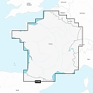
Garmin 010-C1256-20 Cartas Náuticas Navionics+™ de Lagos y Ríos Interiores de Francia Белая
Код товара: t719118
32 106
-

-
Нет в наличии
- Описание и характеристики
- Документация и Сертификаты(0)
- Аудио(0)
- Задать вопрос
| Код производителя | 010-C1256-20 |
| Производитель | Garmin |
| Размер | One Size |
| Код поставщика | 010-C1256-20-138859724-nit |
Описание
It’s A Whole New Look On Your Chartplotter:
- Featuring vibrant colors, a streamlined interface and combined coastal/inland content with a popular Navionics® style color palette, Garmin Navionics+ cartography makes it easy to plot your course with the world’s No. 1 name in marine mapping1.
- Navigate with our best offshore and inland lake coverage for your Garmin chartplotter.
- See it your way. Customize your view with various chart layers and overlay combinations.
- With your included one-year subscription, access daily updates via the ActiveCaptain® smart device app.
- Auto Guidance+™ technology1 lets you navigate with suggested dock-to-dock routings.
- Select up to 10 color-shaded target depth ranges to scope out the best fishing spots.
Plot your paradise on coastal or inland waters.
All-in-one Map Solution For Garmin Chartplotters:
- Access detail-rich mapping of coastal features, lakes, rivers and more. Integrated Garmin and Navionics® content offers coverage for boaters worldwide.
Daily Chart Updates:
- Charts are constantly being enhanced with new and amended content — as many as 5,000 updates are made every day. Your one-year subscription includes access to daily chart updates via the ActiveCaptain app.
Auto Guidance+ Technology:
- Combining the best of Garmin and Navionics automatic routing features, built-in Auto Guidance+ technology1 gives you a suggested dock-to-dock path to follow through channels, inlets, marina entrances and more.
Depth Range Shading:
- High-resolution depth range shading lets you select up to 10 color-shaded options and view your designated target depths at a glance.
Up To 1’ Contours:
- For improved fishing and navigation, up to 1´ contours provide a clear depiction of bottom structure for improved fishing charts and enhanced detail in swamps, canals, harbors, marinas and more.
Shallow Water Shading:
- To give a clear picture of shallow waters to avoid, this feature allows for shading at a user-defined depth.
Raster Cartography:
- NOAA raster cartography2 is available as a free downloadable feature via the ActiveCaptain app to provide paper chart-like views on your plotter.
Activecaptain Community:
- Community-sourced content provides useful POIs, such as marinas, anchorages, hazards, businesses and more. Get recommendations from boaters with firsthand experience of the local environment.
Add premium features with Garmin Navionics Vision+ mapping solutions.
High-resolution Relief Shading:
- This detailed shading feature4 combines color and shadow to give you an easy-to-interpret, clearer view of bottom structure than contour lines alone.
Sonar Imagery:
- The sonar imagery feature4 reveals bottom hardness clearly and in contrasting color, highlighting both subtle and dramatic transition areas on select lakes.
High-resolution Satellite Imagery:
- High-resolution satellite imagery4 provides superior situational awareness.
AErial Photography:
- Crystal-clear aerial and surface photos of ports, marinas, bridges, docks, boat ramps, dams and navigational landmarks provide a better sense of your surroundings above the waterline.
Side-scan Images:
- Side-scan images capture submerged features such as fallen timber, fish attractors, wrecks, potential hazards and more on select U.S. lakes.
3d Fisheye:
- This underwater perspective shows 3D representation of bottom and contours as seen from below the waterline. Interface with sonar data for a customized view.
3d Marinereye:
- This view provides a 3D representation of the surrounding area both above and below the waterline.
Dynamic Lake Level:
- Adjust your maps to the lake’s current water levels to see if spots are accessible or too shallow to explore.
- Add premium features with a Garmin Navionics Vision+™ upgrade.
- Explore which inland lakes are included with Garmin Navionics+™ cartography.
Технические характеристики товара могут отличаться от указанных на сайте, уточняйте технические характеристики товара на момент покупки и оплаты.
Комплектация товара может отличаться от указанной на заглавной фотографии, уточняйте комплектацию на момент покупки и оплаты.
Вся информация на сайте о товарах носит справочный характер и не является публичной офертой в соответствии с пунктом 2 статьи 437 ГК РФ.
Убедительно просим вас при покупке проверять наличие желаемых функций и характеристик.
Задать вопрос
Вы можете задать любой интересующий вас вопрос по товару или работе магазина. Наши квалифицированные специалисты обязательно вам помогут.
Узнать о снижении цены
 Garmin 010-C1256-20 Cartas Náuticas Navionics+™ de Lagos y Ríos Interiores de Francia Белая
Текущая цена: 32 106
Обратная связь
Узнать о поступлении
Узнать цену
Под заказ
Заказ обратного звонка
Благодарим за интерес к товарам нашего магазина! Менеджер связется с Вами в ближайшее время!
Купить всё в 1 клик
Быстрый заказ